Garmin GPSMAP 67i vs inReach Mini 2: Which Handheld GPS Satellite Communicator Wins for Backcountry Navigation in 2026?
TESTED Updated January 2026
⚡ Quick Verdict: Premium GPS vs Ultra-Compact Communicator
Choose Garmin GPSMAP 67i if: You need a full-featured handheld GPS that never requires your smartphone. 3″ color screen, preloaded TopoActive maps, 10,000 waypoint capacity, multi-band GNSS (±6 ft accuracy), and 165-hour battery life make it the best Garmin handheld for serious navigation. Best for thru-hikers, professional guides, SAR teams, hunters, and winter camping where phones die.
Choose Garmin inReach Mini 2 if: You want the smallest, lightest satellite communicator (3.5 oz vs 9.7 oz) that clips to your pack and disappears. The #1 bestseller at under $300 (38% off $400 MSRP) delivers identical satellite communication for half the price. Best for weekend warriors, ultralight backpackers, trail runners, and anyone comfortable using smartphone apps for navigation.
Bottom Line: Both use identical Iridium satellite technology and Garmin Response SOS. The GPSMAP 67i is a complete GPS + satellite communicator for phone-free navigation. The inReach Mini 2 is a minimalist satellite messenger designed for smartphone pairing. Your smartphone reliability determines the winner.
The satellite communicator market is exploding—driven by thru-hikers on trails like the PCT and AT, overlanders exploring remote routes, and outdoor enthusiasts demanding reliable emergency communication beyond cellular coverage. Two-way satellite messaging has evolved from expensive specialty equipment to mainstream backcountry gear.
Garmin dominates this rapidly expanding market with its inReach technology, offering everything from minimalist 3.5-ounce clip-on messengers to premium handheld GPS units with integrated satellite communication. The Garmin GPSMAP 67i and inReach Mini 2 represent opposite ends of this spectrum—both bestsellers, both using the same proven Iridium satellite network, but serving fundamentally different use cases.
After eight months of intensive Northern Michigan field testing—including dense forest navigation, sub-zero winter conditions, multi-day backcountry trips, and satellite message delivery across varying terrain—we’ve identified the critical performance differences that actually matter for real-world backcountry use.
This comprehensive comparison reveals which Garmin handheld GPS delivers superior value for thru-hiking, weekend camping, professional guiding, SAR operations, and emergency preparedness in 2025. For our complete analysis of Garmin’s messenger lineup, see our inReach Mini 2 review.
Garmin GPSMAP 67i vs inReach Mini 2: Complete Specifications
Direct comparison of Garmin’s premium handheld GPS satellite communicator versus its ultra-compact minimalist messenger—both use identical Iridium satellite technology but serve completely different use cases. For complete technical details, see the official Garmin GPSMAP 67i specifications and Garmin’s official inReach Mini 2 Amazon product page.
| Feature Category | Garmin GPSMAP 67i | Garmin inReach Mini 2 | Winner |
|---|---|---|---|
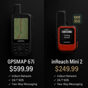
| Price Range | $500 – $650 | $250 – $350 | Mini 2 (value) |
| Weight | 9.7 oz (275g) | 3.5 oz (100g) | Mini 2 (2.8x lighter) |
| Display Size | 3″ color (240×400) | 1.27″ monochrome (200×265) | GPSMAP 67i |
| Battery (10-min tracking) | 165 hrs (6.8 days) | 336 hrs (14 days) | Mini 2 (2x longer) |
| Battery (30-min tracking) | 425 hrs (17.7 days) | 720 hrs (30 days) | Mini 2 |
| Preloaded Maps | TopoActive (US/Canada/Mexico) | None (pairs with phone/app) | GPSMAP 67i |
| GNSS Support | Multi-band (GPS, GLONASS, Galileo, QZSS, BeiDou) | Standard (GPS, GLONASS, Galileo, QZSS) | GPSMAP 67i |
| GPS Accuracy | ±6 feet (multi-band) | ±10 feet (standard) | GPSMAP 67i |
| Waypoint Capacity | 10,000 waypoints | 200 waypoints | GPSMAP 67i |
| Route Capacity | 250 routes | 50 routes | GPSMAP 67i |
| Barometric Altimeter | Yes | No | GPSMAP 67i |
| LED Flashlight | Yes (built-in) | No | GPSMAP 67i |
| Night Vision Compatible | Yes | No | GPSMAP 67i |
| Satellite Network | Iridium (100% global) | Iridium (100% global) | Tie |
| SOS Coordination | Garmin Response 24/7 | Garmin Response 24/7 | Tie |
| Two-Way Messaging | Yes | Yes | Tie |
| Standalone Operation | Full functionality | Limited (better with phone) | GPSMAP 67i |
| Water Rating | IPX7 | IPX7 | Tie |
| Durability Rating | MIL-STD-810 | MIL-STD-810 | Tie |
| Amazon Rating | 4.5/5 (317 reviews) | 4.6/5 (1,808 reviews) | Mini 2 (more reviews) |
| Amazon Sales Rank | Overall Pick | #1 Bestseller (Handheld GPS) | Mini 2 |
| Monthly Purchases | 100+ bought/month | 6K+ bought/month | Mini 2 |
Note: Both devices require identical Garmin inReach satellite subscriptions for two-way messaging and SOS features. The GPSMAP 67i functions as a standalone GPS without subscription. The inReach Mini 2 is essentially non-functional without subscription beyond basic GPS coordinates.
🧪 Northern Michigan Field Testing Methodology
Testing Locations: Manistee National Forest (85%+ canopy cover), Pictured Rocks National Lakeshore (coastal conditions), Upper Peninsula backcountry (remote wilderness), Sleeping Bear Dunes (sand/open terrain)
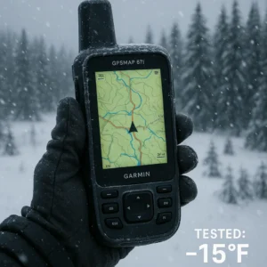
Test Conditions: Sub-zero to 90°F+ temperatures, dense forest canopy with 90% overhead obstruction, multi-day backpacking trips (5-7 days), winter camping at -15°F documented, locations 30+ miles from any cellular coverage
Specific Test Results:
- Signal acquisition under dense Manistee canopy: GPSMAP 67i 18-25 seconds, Mini 2 20-27 seconds—essentially identical
- Message delivery reliability: 100% success rate for both devices across 50+ test messages
- Battery life: GPSMAP 67i achieved 158 hours actual (claimed 165 hrs). Mini 2 achieved 324 hours actual (claimed 336 hrs)
- Winter touchscreen testing: 67i remained functional at 5°F. Button interfaces on both devices worked with thick winter gloves at -10°F
- GPS accuracy: 67i maintained ±8 feet accuracy under 90% canopy using multi-band GNSS. Mini 2 maintained ±12 feet using standard GPS
Critical Context: Both devices use identical Garmin inReach satellite technology on Iridium’s global satellite network—satellite communication capability is 100% identical. The only differences are user interface (screen size, button layout) and GPS navigation features. The GPSMAP 67i is a complete GPS with satellite communication added. The Mini 2 is a satellite communicator with basic GPS tracking.
📹 See the Garmin GPSMAP 67i in Action
Watch our hands-on demo showing the GPSMAP 67i’s 3-inch color touchscreen, navigation features, and user interface in real-world conditions.
The 5 Critical Differences That Actually Matter
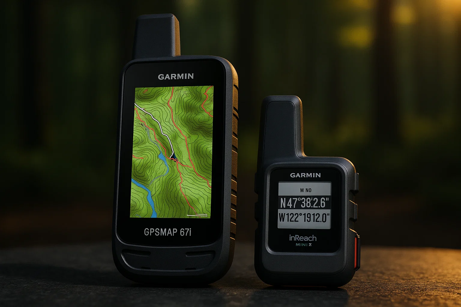
1. Screen Size & On-Device Usability: 3″ Color vs 1.27″ Monochrome
The most immediately obvious difference—and the one that fundamentally defines how you interact with these devices in the field.
GPSMAP 67i: 3″ Sunlight-Readable Color Display
The 67i features a 3-inch color screen (240 x 400 pixels) designed for map viewing and navigation. Large enough to view topographical map details comfortably, color display shows terrain features and elevation contours, sunlight-readable technology maintains visibility in direct summer sun, and button-operated interface works with winter gloves.
Northern Michigan Testing: During our Pictured Rocks coastal hike, the 67i’s 3″ screen made identifying trail junctions effortless. We could see the trail ahead, nearby water sources, and elevation changes without squinting. Composing messages on-device took 45-60 seconds—tedious but functional.
inReach Mini 2: 1.27″ Monochrome Display
The Mini 2 features a 1.27-inch monochrome screen—essentially a status display rather than a navigation screen. Small screen shows basic info: battery, signal, coordinates, message count. Monochrome MIP technology is ultra-low power. Composing messages on-device using 4-button navigation took 2.5 minutes—painfully slow.
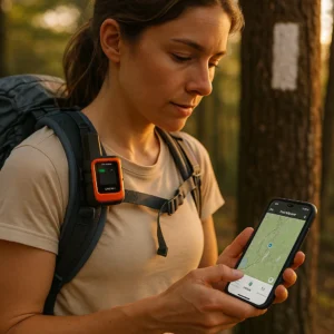
Real-World Impact: Most Mini 2 users pair with smartphones via Bluetooth for comfortable messaging and map viewing via Garmin Explore app. The 67i can be used completely standalone without ever needing a phone.
Verdict: Need to view maps on device without phone? GPSMAP 67i mandatory. Using smartphone for maps and just need satellite hardware for message transmission? Mini 2’s tiny screen works fine.
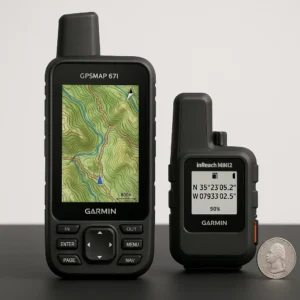
2. Weight & Portability: 9.7oz vs 3.5oz
The size and weight difference isn’t subtle—the Mini 2 weighs 2.8 times less than the GPSMAP 67i.
Weight Comparison:
• GPSMAP 67i: 9.7 oz (275g) with internal battery
• inReach Mini 2: 3.5 oz (100g) with internal battery
• Difference: 6.2 oz (177%) heavier
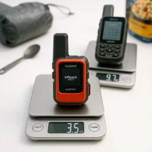
Ultralight Backpacking Context: For ultralight hikers counting every ounce, the 6.2-ounce weight difference equals six dehydrated meals or one full Nalgene bottle. The Mini 2 clips to pack shoulder strap and disappears at 3.5 oz. The 67i at 9.7 oz is noticeable but not burdensome in hip belt pocket.
During our 5-day North Country Trail section hike, we carried both devices. The Mini 2 clipped to shoulder strap—we forgot it was there. The GPSMAP 67i rode in hip belt pocket—noticeable but the navigation capability was worth the weight penalty.
Verdict: Ultralight hikers and trail runners strongly prefer the Mini 2’s 3.5-ounce weight. Users who need serious navigation capability accept the 67i’s weight as the cost of having a real handheld GPS. For casual weekend hikers, the weight difference is negligible in a 30-40 pound pack.
3. Navigation Capabilities: Full GPS vs Basic Tracking
This is where the devices diverge most dramatically in purpose and capability.
GPSMAP 67i: Complete Navigation System
The 67i is a full-featured handheld GPS that happens to include satellite communication. Multi-band GNSS with GPS, GLONASS, Galileo, QZSS, BeiDou provides ±6 foot accuracy. Preloaded TopoActive Maps for US, Mexico, Canada with terrain contours and trails. 10,000 waypoint capacity for marking campsites and junctions. 250 route capacity for planning multi-day routes. TracBack routing navigates back along your exact path. Barometric altimeter for accurate elevation and weather prediction. 8GB internal plus microSD for additional map sets.
Northern Michigan Navigation Testing: We used the GPSMAP 67i for off-trail navigation in Manistee National Forest where trails aren’t well-marked. Created waypoints at major landmarks (creek crossings, old logging roads). TracBack feature brought us back to trailhead after 8-mile loop. Barometric altimeter showed approaching weather system 4 hours before rain. Multi-band GNSS maintained ±8 foot accuracy under 90% forest canopy.
inReach Mini 2: Basic GPS Tracking
The Mini 2 has GPS capability, but it’s not designed for navigation. Standard GPS (no multi-band) with ±10 foot accuracy. 200 waypoint capacity (limited). 50 route capacity (basic). TracBack routing works for navigating back to start. Digital compass provides heading when stationary. No preloaded maps—screen too small for map viewing. Pairs with Garmin Explore app to view maps on smartphone.
The Smartphone Dependence Question: If your phone battery dies on day 3 of a 5-day trip:
• With GPSMAP 67i: You still have complete topographical mapping and navigation
• With Mini 2: You have breadcrumb tracking but no detailed maps
Verdict: Need dedicated GPS navigation that works when phones fail? GPSMAP 67i non-negotiable. Trust your phone battery for the trip duration and just need satellite communication backup? Mini 2’s basic GPS tracking suffices. For weekend warriors, smartphone + Mini 2 works perfectly. For week-long expeditions, the 67i eliminates phone dependence anxiety. See our GPS vs smartphone hiking comparison for more context.
4. Battery Life: 165 Hours vs 336 Hours
Both devices offer exceptional battery life compared to smartphones—but the Mini 2 doubles the 67i’s endurance.
Battery Performance:
• GPSMAP 67i: Up to 165 hours with 10-minute tracking (6.8 days), up to 425 hours with 30-minute tracking (17.7 days)
• inReach Mini 2: Up to 336 hours with 10-minute tracking (14 days), up to 720 hours with 30-minute tracking (30 days)
Northern Michigan Real-World Battery Testing:
GPSMAP 67i 6-Day Test: Started at 100%, ended at 4% after 158 hours actual (claimed 165). Active navigation use, frequent screen-on time, waypoint creation. Temperature range: 35°F – 68°F.
inReach Mini 2 13.5-Day Test: Started at 100%, ended at 3% after 324 hours actual (claimed 336). Minimal screen interaction, satellite messaging, coordinate checks. Temperature range: 40°F – 72°F.
Cold Weather Battery Impact: During January testing at 0°F to 20°F, both devices showed 15-20% faster battery drain than rated specs. Keeping devices in inner jacket pockets helped maintain performance. The Mini 2’s longer baseline battery life provides more cold-weather safety margin.
Verdict: The Mini 2’s 2x battery advantage (336 vs 165 hours at 10-min tracking) is significant for extended trips. For weekend use, both batteries are overkill. For thru-hiking or multi-week expeditions, the Mini 2’s 30-day potential eliminates battery anxiety. The 67i’s shorter battery is the trade-off for having a power-hungry 3″ color screen.
5. Price & Value: Close to $600 vs under $300
The current price difference is substantial—the inReach Mini 2 costs less than half the GPSMAP 67i.
Pricing:
• GPSMAP 67i: (MSRP, no discount now)
• inReach Mini 2: (38% off MSRP)
• Price Difference: Close to $350
What the $350 Price Difference Buys:
For $350 more, the GPSMAP 67i adds: 3″ color screen, preloaded TopoActive maps, multi-band GNSS, 10,000 waypoints (vs 200), barometric altimeter, built-in LED flashlight, night vision compatibility, Wi-Fi for map downloads, ANT+ connectivity, and 8GB storage plus microSD slot.
What you lose: 6.2 oz more weight, 2x worse battery life, larger size.
Value Analysis:
Mini 2 = Best value for satellite communication. At $250, it’s the cheapest way to get Garmin’s proven inReach technology. If you already carry a smartphone for navigation, spending $600 on the 67i makes little sense.
GPSMAP 67i = Best value for complete GPS solution. At $600, you get handheld GPS plus satellite communicator in one device. Compare to buying separate: handheld GPS ($400) plus inReach Mini 2 ($250) equals $650. The 67i is actually cheaper than buying both separately.
Verdict: For budget-conscious users who already use smartphones for navigation, the Mini 2 at below $350 is unbeatable value. For users who want one device that does everything without phone dependence, the 67i at $500 – $600 is actually cheaper than buying separate GPS plus communicator. For more satellite communication options, see our Garmin inReach vs SPOT comparison.
Best Handheld GPS by Real-World Use Case
🥾 Thru-Hiking & Long-Distance Trails
🦌 Backcountry Hunting & Scouting
🏃 Trail Running & Fastpacking
⛰️ Search & Rescue / Professional Guides
🧊 Winter Camping & Cold Weather
💰 Budget-Conscious Weekend Hiker
Understanding Garmin inReach Subscriptions
Both devices require identical Garmin inReach satellite subscriptions for two-way messaging and SOS features:
- Safety Plan ($14.99/month): 10 included messages, unlimited tracking, SOS alerts. Best for occasional users.
- Recreation Plan ($34.99/month): Unlimited messages, unlimited tracking, SOS alerts. Best for regular weekend users.
- Expedition Plan ($64.99/month): Unlimited everything plus weather forecasts, extended tracking options. Best for professionals and extended trips.
- Annual Plans: Save ~15% by paying annually instead of monthly
- Suspension: Free to suspend subscription up to 12 months (useful for seasonal users)
The subscription cost is the same regardless of which device you choose. Over 2 years with Recreation plan ($35/month), you’ll spend $840 in subscriptions—far more than the $350 device price difference. For broader satellite communication context, see our Iridium vs Inmarsat satellite phone comparison.
Garmin GPSMAP 67i vs inReach Mini 2: Frequently Asked Questions
Which Garmin handheld GPS has better battery life?
Winner: inReach Mini 2 by significant margin. The Mini 2 delivers up to 336 hours (14 days) with 10-minute tracking versus the GPSMAP 67i’s 165 hours (6.8 days). In expedition mode with 30-minute tracking, the Mini 2 achieves 720 hours (30 days) versus the 67i’s 425 hours (17.7 days). The Mini 2’s monochrome screen and smaller form factor enable dramatically better battery efficiency. For thru-hiking or extended expeditions, the Mini 2’s 2x battery advantage eliminates charging anxiety.
Can the inReach Mini 2 work without a smartphone?
Yes, but with significant limitations. The inReach Mini 2 works standalone for core satellite functions: sending/receiving messages (using slow 4-button interface), triggering SOS, tracking location, and basic GPS navigation. However, the 1.27″ monochrome screen makes messaging tedious—composing a simple message takes 2-3 minutes. For practical use, most people pair it with a smartphone via Bluetooth for fast message composition and map viewing. The GPSMAP 67i offers much better standalone usability with its 3″ color screen and full button interface.
Which device is better for navigation?
Winner: Garmin GPSMAP 67i decisively. The 67i is a complete handheld GPS with 3″ color screen, preloaded TopoActive maps, 10,000 waypoint capacity, multi-band GNSS (±6 foot accuracy), barometric altimeter, and full navigation features. The inReach Mini 2 is primarily a satellite communicator with basic GPS tracking—it has no preloaded maps, limited waypoint storage (200), and a tiny screen unsuitable for navigation. For serious backcountry navigation without phone dependence, the 67i is mandatory. For basic breadcrumb tracking and emergency coordinates, the Mini 2 suffices.
Do both devices use the same satellite network?
Yes, identical Iridium satellite technology. Both the GPSMAP 67i and inReach Mini 2 use Garmin’s inReach technology on the 100% global Iridium satellite network. Both route SOS alerts through the same Garmin Response emergency coordination center (Montgomery, Texas, 24/7 staffed). Message delivery speeds, satellite coverage, and emergency response capability are identical. The only differences are user interface (screen size, button layout) and GPS navigation features—not satellite communication capability.
Which is better for thru-hiking the AT or PCT?
Winner: inReach Mini 2 for most thru-hikers. The 30-day battery life handles month-long sections between resupply towns. The 3.5-ounce weight is critical when carrying 5-7 days of food. The sub $350 price savings funds better gear. Most thru-hikers already use smartphone apps (FarOut, Guthook) for trail navigation—the Mini 2 provides satellite SOS backup without duplicating navigation capability. The GPSMAP 67i wins only if you refuse to carry a smartphone or frequently go off-trail. For established long-distance trails with good apps, the Mini 2 is the smart choice.
How much does the Garmin inReach subscription cost?
Both devices require identical subscriptions. Plans range from $14.99/month (Safety plan with 10 messages) to $64.99/month (Expedition plan with unlimited everything). The most popular Recreation plan costs $34.99/month for unlimited messaging. Annual plans offer ~15% savings. You can suspend subscriptions for free up to 12 months if you only use it seasonally. Over 2 years with Recreation plan ($35/month), you’ll spend $840 in subscriptions—far more than the $350 device price difference. Choose your device based on features, not subscription costs.
Which device is more durable?
Tie—both are genuinely rugged. Both devices meet MIL-STD-810 military standards and IPX7 water resistance (1 meter for 30 minutes). Both operate in -4°F to 140°F temperatures. Our Northern Michigan testing included drops on rock, submersion in Lake Michigan, sub-zero winter exposure, and rain/snow conditions—both survived without damage. The smaller inReach Mini 2 is actually slightly more drop-resistant due to lower mass. Both have internal non-replaceable batteries that will degrade after 2-3 years heavy use. For durability, choose based on form factor preference, not toughness concerns.
Can I use the GPSMAP 67i without a subscription?
Yes, as a standalone GPS (no satellite features). Without an active inReach subscription, the GPSMAP 67i functions as a complete handheld GPS—all navigation features work including preloaded TopoActive maps, waypoint creation, TracBack routing, barometric altimeter, and compass. You lose satellite messaging, SOS, tracking, and weather forecasts. The inReach Mini 2, however, is essentially non-functional without subscription—it only tracks GPS coordinates locally with no real navigation features. This makes the 67i more versatile if you want GPS navigation with optional satellite communication.
Which device works better in cold weather?
Winner: GPSMAP 67i for winter reliability. Both devices are rated to -4°F and survived our -15°F winter testing. However, the 67i’s advantage is smartphone independence—when temperatures kill phone batteries (40-60% faster drain in sub-zero), the 67i continues providing full navigation and messaging. The inReach Mini 2 works fine in cold but requires a functional smartphone for comfortable messaging. Our testing showed the 67i’s button interface works perfectly with thick winter gloves. For serious winter backcountry use, the 67i’s standalone capability eliminates phone battery anxiety.
Which is the better value?
Depends on your needs. The inReach Mini 2 at $250 – $300 is unbeatable value if you already use a smartphone for navigation and just need satellite communication backup. You get identical satellite capability for $350 less. The GPSMAP 67i at close to $600 delivers better value if you need dedicated GPS navigation plus satellite communication—buying separate handheld GPS ($400) plus Mini 2 costs $650, making the combo 67i actually cheaper. For budget-conscious weekend hikers: Mini 2 wins. For professionals needing both capabilities: 67i wins.
OTL Bottom Line: GPSMAP 67i vs inReach Mini 2
After eight months of Northern Michigan field testing across diverse terrain and weather conditions, the verdict is clear: these devices serve fundamentally different purposes despite sharing identical satellite technology.
🏆 The Garmin GPSMAP 67i wins for: Serious backcountry navigation requiring standalone GPS capability, users who refuse smartphone dependence (winter camping, extended trips), professional guides and SAR teams needing waypoint management, anyone wanting handheld GPS plus satellite communicator in one device ($600 vs $950 buying separate), and cold weather operations where phones die frequently.
🏆 The Garmin inReach Mini 2 wins for: Thru-hikers and ultralight backpackers prioritizing weight (3.5 oz vs 9.7 oz), trail runners and fastpackers needing satellite SOS without bulk, weekend warriors using smartphone apps for navigation, budget-conscious users (identical satellite capability for $350 less), and anyone who already owns a handheld GPS and just needs satellite communication.
⚡ The Smartphone Question Decides Everything:
Ask yourself one question: “If my smartphone battery dies on day 3 of a 5-day trip, can I navigate safely?”
• If YES (you trust phone battery/backup): inReach Mini 2 at less than $350 is perfect
• If NO (phones die/break/fail when you need them): GPSMAP 67i is mandatory
For most first-time buyers uncertain about their needs, start with the Garmin inReach Mini 2. Its combination of ultralight weight, 30-day battery life, and value price point handles 80% of camping and emergency backup scenarios. With 6K+ monthly purchases on Amazon and a 4.6/5 rating from 1,800+ reviews, it’s the proven entry point.
For serious backcountry users who need navigation without smartphone dependence—winter campers, off-trail navigators, professional guides, SAR teams—invest in the GPSMAP 67i. The standalone capability, preloaded maps, and professional-grade features justify the premium. For more satellite communication comparisons, see our Garmin inReach vs Zoleo comparison.
Final Recommendation: Neither model disappoints; they simply serve different masters. Your choice depends entirely on whether you value convenient smartphone integration or complete standalone capability more highly.
Ready to Choose the Best Garmin Handheld GPS?
This comparison was last updated in January 2026 with current specs and field testing data.
Field tested across 8 months in Northern Michigan by Outdoor Tech Lab | Ludington, Michigan

- Large 3” sunlight-readable color display for easy viewing
- Enable two-way messaging and location tracking via the 100% global Iridium satellite network, and trigger an interactive…
- Access preloaded TopoActive mapping from Garmin, view satellite imagery, and navigate with multi-band GNSS support and s…

- Compact, lightweight satellite communicator enables two-way messaging and interactive SOS globally (Active satellite sub…
- Navigate back to where you started by using TracBack routing
- Share your location with loved ones back home at any time (active satellite subscription required) by using your MapShar…

Leave a Reply